The network of largely single-track roads within a radius of 10-15 miles around Kilnwick provides a rich variety of routes for leisure cycling, giving magnificent views of an ever-changing countryside and providing unrivalled opportunities for modest exercise for those who wish to keep fit. The topography is unchallenging. Because of this, routes are accessible to all, from young to old, for individuals and family groups. Some of the routes are ‘there-and-back’ whilst others are partially or wholly circular. Whichever you choose, you will be richly rewarded by the scenery you encounter.
Kilnwick to South Dalton Figure of Eight
Length: 9 miles (14.37 km); Total Amount of Rise: 281 ft (85.8 m)
Start & Finish: All Saints Church, Church Lane, Kilnwick, National Grid Reference: SE997496
Map: OS Landranger Sheet 106 (Market Weighton)
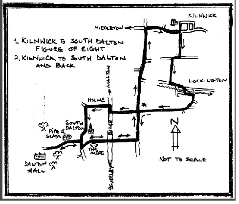
Starting at All Saints Church, head south for 200 yards up Church Lane, Kilnwick. At the crossroads with Middleton Road (C59), go straight over and head up Lockington Lane for about 900 yards until you hit the T-junction with Beswick Heads. Turn right (west) and then, almost immediately, turn left (south) down Kilnwick Lane until you reach a T-junction with Front St, Lockington. Turn left (southeast) onto Front St and after about 300 yds, take a right either through the water splash (N.B. this is the second water splash you will see along Front St) or, if the water is too deep, cross the footbridge to pass the Village Hall (The Old School) and turn left (southeast) onto Chapel St. After about 100 yds, turn right into Thorpe and continue beyond the village for about a mile-and-a-half until you reach a T-junction with the Malton Rd (B1248). Turn right (north) and, after 100 yards, turn left (west) towards Holme-on-the-Wolds. Traffic-wise, this short stretch is likely to be the most challenging because it is the only bit of main road on the route. [If you have small children in the party and want to avoid any busy roads, see the alternative ride, Kilnwick to South Dalton and Back, below.]
After 600 yards, you arrive in Holme. Here, follow the road as it turns left (south). Beware! A right turn (i.e. straight on), takes you out onto Holme Wold and beyond – see the ride: Kilnwick to Lund Warren, Lund and Back. After about 700 yards, you pass South Dalton Church. If the Church is open, this is well worth a visit. The spire of 203 ft (62 m) is impressive and almost unique to this part of The East Riding, mimicked only by the diminutive spire of Scorborough – most of the Riding’s ancient churches have towers, not spires. On the north side of the chancel, look for the replica skeleton marking the resting place of a Hotham ancestor.
From the Church, head south a hundred yards or so. Here, if you have time, you can turn right onto West End. If the Pipe and Glass is open and the sun is shining, enjoy refreshments on the picnic benches outside; and/or, pass through the gate into the parkland drive that passes Dalton Hall, the magnificent Georgian family seat of Lord Hotham.
If you have no time for a diversion, from the church, keep going south beyond West End along Main St for another 80 yards and turn left (east) along Mere Lane. A few hundred yards up Mere Lane, stop to see if you can spot the ghost koi carp that swim in the village pond - The Mere – or admire (but don’t feed!) the water fowl. Continue east along Mere Lane for 800 yards until you reach a crossroad with the Malton Rd (B1248). Go straight over, heading east. After about 500 yards, turn left at a T-junction and head north past Lockington Grange until you reach a crossroads. (You’ve already seen this from a different perspective on your way from Lockington to Holme!). Go straight across, following the sign to Bracken. After about 2½ miles, you arrive at the Middleton Rd (C59), a cross-road. Turn right (east) and, after about a mile, you are back in Kilnwick. Turn left into Church Lane to arrive at your starting point.
Kilnwick to South Dalton and Back
Length: 9.4 miles (15 km); Total Amount of Rise: 274 ft (83.7 m)
Start & Finish: All Saints Church, Church Lane, Kilnwick, National Grid Reference: SE997496
Map: OS Landranger Sheet 106 (Market Weighton)
This is a variant of Kilnwick to South Dalton Figure of Eight and is designed to avoid the 100 yards of travel along the Malton Rd (B1248). It may be safer for parties that include small children. Much of the first two and a half miles follows the same route as the ride Kilnwick to South Dalton Figure of Eight, as do the last five miles.
Starting at All Saints Church, head south for 200 yards up Church Lane, Kilnwick. At the crossroads with Middleton Road (C59), go straight over and head up Lockington Lane for about 900 yards until you hit the T-junction with Beswick Heads. Turn right (west) and then, almost immediately, turn left (south) down Kilnwick Lane until you reach the T-junction with Front St, Lockington. Turn left (southeast) onto Front St and after about 300 yds, take a right either through the water splash (N.B. this is the second water splash you will see along Front St) or, if the water is too deep, cross the footbridge to pass the Village Hall (The Old School) and turn left (southeast) onto Chapel St.
After about 100 yds, turn right into Thorpe and continue beyond the village for about a mile or so until you come to a crossroad. If you want a shorter ride, you can turn right (north) here (see * on sketch map) and proceed back to Kilnwick via Bracken Lane and Middleton Road. If you are aiming to reach South Dalton, turn left (south) in the direction signed “Beverley”. After a mile, take a right turn (west) towards South Dalton and, after 500 yards, go straight across the crossroads at the Malton Rd (B1248). After 800 yards, stop to see if you can spot the ghost koi carp that swim in the village pond - The Mere – or admire (but don’t feed!) the water fowl. Continue west along Mere Lane for 100 yards to the T-junction with Main St, South Dalton. Turn right (north). After 80 yards, you reach West End. Here, if you have time, you can turn left (west) onto West End. If the Pipe and Glass is open and the sun is shining, enjoy refreshments on the picnic benches outside; and/or, pass through the gate into the parkland drive that passes Dalton Hall, the magnificent Georgian family seat of Lord Hotham.
Turn around, passing the Pipe and Glass, and cycle back up West End to the T-junction with Main St. Turn left (north) and, after 100 yards, you come to South Dalton Church. If the Church is open, this is well worth a visit. The spire of 203 ft (62 m) is impressive and almost unique to this part of The East Riding, mimicked only by the diminutive spire of Scorborough – most of the Riding’s ancient churches have towers, not spires. On the north side of the chancel, look for the replica skeleton marking the resting place of a Hotham ancestor.
Once you’re ready, head for Kilnwick, first cycling a couple of hundred yards southwards back down Main St and take the first left along Mere Lane. From The Mere, continue east along Mere Lane for 800 yards until you reach the crossroad with the Malton Rd (B1248). Go straight over, heading east. After about 500 yards, turn left at a T-junction and head north past Lockington Grange until you reach a crossroads. (You’ve already seen this from a different perspective on your way from Lockington). Go straight across, following the sign to Bracken. After about 2½ miles, you arrive at the Middleton Rd (C59), a cross-road. Turn right (east) and, after about a mile, you are back in Kilnwick. Turn left into Church Lane to arrive at your starting point.
Kilnwick to Lund Warren, Lund and Back
Length: 11.25 miles (18 km); Total Amount of Rise: 351 ft (107 m)
Start & Finish: All Saints Church, Church Lane, Kilnwick, National Grid Reference: SE997496
Map: OS Landranger Sheet 106 (Market Weighton)
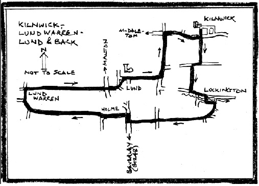
Starting at All Saints Church, head south for 200 yards up Church Lane, Kilnwick. At the crossroads with Middleton Road (C59), go straight over and head up Lockington Lane for about 900 yards until you hit the T-junction with Beswick Heads. Turn right (west) and then, almost immediately, turn left (south) down Kilnwick Lane until you reach a T-junction with Front St, Lockington. Turn left (southeast) onto Front St and after about 300 yards, take a right either through the water splash (N.B. this is the second water splash you will see along Front St) or, if the water is too deep, cross the footbridge to pass the Village Hall (The Old School) and turn left (southeast) onto Chapel St. After about 100 yds, turn right into Thorpe and continue beyond the village for about a mile-and-a-half until you reach a T-junction with the Malton Rd (B1248). Turn right (north) and, after 100 yards, turn left (west) towards Holme-on-the-Wolds. Traffic-wise, this short stretch is likely to be the most challenging because it is the only bit of main road on the route. If you have small children in the party, you might wish to dismount and walk along the verge, being ever-conscious of fast-moving traffic.
After 600 yards, you arrive in Holme. Turn right (i.e. straight on). This is where rural East Yorkshire becomes even more rural – you are heading for Holme Wold, once a fully wooded landscape, now, after 900 years of post-Medieval agriculture, giving far reaching views across cultivated fields towards the crest of the Chalk cuesta. Follow this road for 1½ miles to a T-junction. Look out for red kites. Once at the junction, turn right (northwest) and, 300 yards on, at the next T-junction, turn right (north). This is Lund Warren – the name a testimony to an 18th Century animal husbandry no longer important. Drop down the hill for 200 yards and turn right (northeast) to climb out of the dry valley and reach an altitude of 220 ft (67m), the highest point on the ride. From here, it is virtually all downhill as you cycle eastwards down the dipslope of the Wolds.
After 1½ miles, cross over the Beverley-Malton road (B1248) and enter Lund, passing the pond and following the road round to the left, arriving at the village Green. Turn right off Main Street, keeping the Green on your left. If the Wellington Inn is open (http://www.thewellingtoninn.co.uk ), here is an opportunity for refreshments. From the Wellington Inn, follow Lockington Lane downslope and eastwards out of the village. After ¾ mile, at a T-junction, turn left (north) and follow Bracken Lane for 1 mile until you reach a crossroads. This is the Middleton Road (C59). Turn right (east) and, after 900 yards, enter Kilnwick. Turn left into Church Lane to arrive at your starting point.
Kilnwick to Kirkburn and Back
Length: 10.2 miles (15.4 km); Total Amount of Rise: 304 ft (93 m)
Start & Finish: All Saints Church, Church Lane, Kilnwick, National Grid Reference: SE997496
Map: OS Landranger Sheet 106 (Market Weighton)
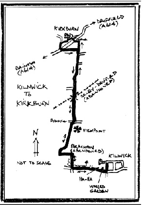
Starting at All Saints Church, head south for 200 yards up Church Lane, Kilnwick. At the crossroads, turn right (west) onto Middleton Road (C59). Follow the road for about 900 yards until you reach a crossroad. On the way, you will have skirted two sides of the 16 ft (5 m) Walled Garden of Kilnwick House, one of the former country seats of the Grimston family. Once west of the wall, you might glimpse the 18th century brick ha-ha that lines the ditch on the north side of the road. The purpose of a ha-ha was to allow uninterrupted views of the estate from the house whilst keeping sheep and cattle off the adjacent pasture. Glance beyond the pasture and you will see what remains of the House, still grand even without its Georgian frontage, which was demolished after its sale in the 1950s.
Once you arrive at the crossroads mentioned earlier, turn right (north), crossing Bracken Beck. After 400 yards, the road makes an abrupt left-turn and as you cycle west, note the uneven ‘made’ ground in the field on your right – this is the site of Bracken, once a thriving hamlet, now long abandoned. The road takes another abrupt turn, this time to the right (north) and, once through the farm buildings, you're heading up onto the local Wold. After about 1 mile of moderately strenuous climbing and about 100 yards short of a junction, you reach a local summit at 154 ft (47 m). This provides arguably the best all-round view in this part of The Riding. If the air is clear, you can see for miles out over Holderness. Look northeast and pick out the Fraisthorpe and Lisset wind farms near Bridlington (13 miles, 21 km); swing clockwise, round to the eastsoutheast, to see the Hatfield turbines south of Hornsea; to the southeast, at a distance of 20 miles (32 km) is the cooling tower at Saltend on the Humber and, a little further round, at 9 miles (14 km), the towers of Beverley Minster; continue traversing to pick out the 203 ft (62 m) spire of South Dalton church and, on the ridge-line of the Wolds above Sancton, the clutch of turbines.
When it’s time to move on, cycle 100 yards north to the junction and, following the tarmac (one of the turns – one that you don’t want, is a rough-track byway), turn left (north), dropping of the ridge. After 500 yards, ride up and over the line of the Market Weighton-Driffield railway, abandoned since the ‘Beeching cuts’ to the rail network of the 1960s. Continue north, passing the turn to Neswick (another former country seat of the Grimston family), until you reach a junction with the A614 and go straight across, entering Kirkburn. After 60 yards, you can either turn right and gaze down at the clear waters of the spring-fed burn, or turn left (west) and wend your way through the village. If time permits, check out the church and its Norman font. Otherwise, proceed to a T-junction and turn left (south) to reach a crossroad with the A614. Go diagonally across the A614 and cycle 500 yards along Gravelpit Lane to a T-junction. You’ve already seen this from a different angle whilst heading for Kirkburn. Turn right (south) and retrace your route back to Kilnwick.
The Burn Butts Loop from Kilnwick
Length: 6¼ miles (10 km); Total Amount of Rise: 161 ft (49 m)
Start & Finish: All Saints Church, Church Lane, Kilnwick, National Grid Reference: SE997496
Map: OS Landranger Sheet 106 (Market Weighton)
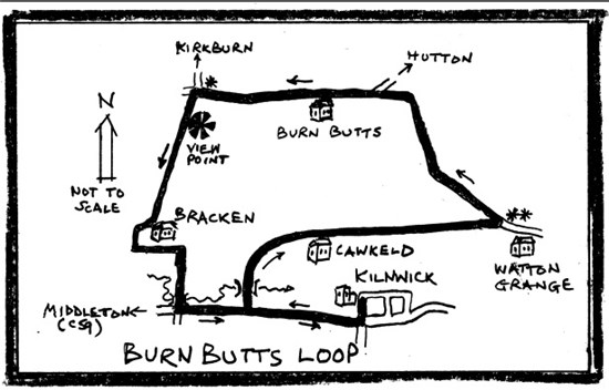
This is a short ride with fantastic views over Holderness and the dipslope of the Wolds. If, having set out, you decide to go further, this circuit intersects the ride Kilnwick to Kirkburn and Back (see * on sketch map).
Starting at All Saints Church, head south for 200 yards up Church Lane, Kilnwick. At the crossroads, turn right (west) onto Middleton Road (C59). Follow the road for about 500 yards until you reach a right-turn – Crabtree Lane. On the way, you will have skirted two sides of the 16 ft (5 m) high Walled Garden of Kilnwick House, one of the former country seats of the Grimston family. Once west of the wall, you might glimpse the 18th century brick ha-ha that lines the ditch on the north side of the road. The purpose of a ha-ha was to allow uninterrupted views of the estate from the house whilst keeping sheep and cattle off the adjacent pasture. Glance beyond the pasture and you will see what remains of the House, still grand even without its Georgian frontage, which was demolished after its sale in the 1950s.
Once you arrive at Crabtree Lane, mentioned earlier, turn right (north), crossing Bracken Beck - from this point and downstream, dubbed Kilnwick Beck as it flows to join the River Hull via Watton Beck. After 500 yards, the road veers to the right and passes Cawkeld – described when the Kilnwick Estate was sold in the 1950s as one of the best farms in The Riding. Continue eastwards for ¾ mile until you arrive at Watton Grange. Straight on leads to Watton and the ride Kilnwick, Watton and Tophill Low (see ** on sketch map). For now, take a left turn that almost, but not quite, doubles back on the way you’ve come and proceed northwest up the hill for about a mile. As you gain height, glance to the right. Although there’s now little to see, you can appreciate the setting of the wartime Hutton Cranswick AirField out of which flew RAF Fighter Command 302, 306 308, 315 and 316 (Polish) Squadrons.
At the top of the rise, the road bends sharply left (west). Continue past Burn Butts for about 1 mile. At a junction, keep to the road you are on i.e. follow the road as it turns sharp left; don’t turn right or go straight on, onto the rough track byway. If you have decided you need more of this magnificent countryside, this is the intersection with the ride Kilnwick to Kirkburn and Back and you will turn right towards Southburn and Kirkburn (see * on sketch map).
If you are continuing on The Loop and returning direct to Kilnwick, follow the road as it swings left (southward). After about 100 yards, you reach a local summit at 154 ft (47 m). This provides arguably the best all-round view in this part of The Riding. If the air is clear, you can see for miles out over Holderness. Look northeast and pick out the Fraisthorpe and Lisset wind farms near Bridlington (13 miles, 21 km); swing clockwise, round to the eastsoutheast, to see the Hatfield turbines south of Hornsea; to the southeast, at a distance of 20 miles (32 km) is the cooling tower at Saltend on the Humber and, a little further round, at 9 miles (14 km), the towers of Beverley Minster; continue traversing to pick out the 203 ft (62 m) spire of South Dalton
church and, on the ridge-line of the Wolds above Sancton, the clutch of turbines. Look to the northnorthwest and see if you can spot Sir Tatton Sykes’ Monument up near Sledmere House. But, above all, soak up the views of The Yorkshire Wolds.
From here, it’s almost ‘all downhill’! Enjoy one of the longest shallow-gradient descents local to Kilnwick as you move towards the ‘lost’ hamlet of Bracken. Wiggle through Bracken until you reach the crossroads with Middleton Rd (C59), having just crossed Bracken Beck. Turn left (east) and after 900 yards you are back in Kilnwick. Turn left (north) into Church Lane and arrive back where you started.
Wilfholme Landing from Kilnwick – Backend of Beyond!
Length: 10 miles (15.8 km); Total Amount of Rise: 141 ft (43 m)
Start & Finish: All Saints Church, Church Lane, Kilnwick, National Grid Reference: SE997496
Maps: OS Landranger Sheets 106 (Market Weighton) and 107 (Kingston upon Hull)
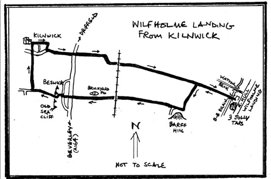
This ride takes you out onto Holderness to the banks of the River Hull. If you want temporarily to retreat from the world, this is a ‘must’.
Starting at All Saints Church, head north for 60 yards down Church Lane, Kilnwick, and follow the road into Main Street and up to Tibby Corner, where Tibby Lane takes you south to its junction with Wilfholme Lane (C59). Turn left and, after ¾ mile, go straight across the Beverley-Driffield road, the A164. After a further ¾ mile, cross the Beverley-Driffield railway and move out onto the one-time seasonally inundated swamplands of low-lying Holderness. Look out for buzzards, hobbies and, if you’re lucky, a peregrine falcon. At different seasons, there will be flocks of lapwings, starlings, curlews and fieldfares and you might be treated to over-flights of geese, ducks and swans, both mute and Hooper. After 2½ miles, you arrive at Wilfhome Landing.
This is the end of the road and, although you may not be alone, it feels a long, long way from the hurly-burly. Park your bike and wander quietly up onto the levée of the River Hull. As your head gets level with the top of the levée, first check for flocks of black-headed gulls, the odd glaucus gull, a single little egret (probably too far north for comfort), little grebes that are diving for fish, etc. If you’re lucky, you might catch a glimpse of a kingfisher, or an otter; and, at the time of writing, there is a resident, if rarely-seen, grey seal that plies up and down the river between Hempholme Lock and Arram. Occasionally, depending on previous rainfall, you might be conscious of the noise from the pumping station. This is taking water from the Beverley-Barmston Drain, which you crossed before parking your bike, which parallels the river and was constructed in the late 18th and early 19th centuries to convert the landscape you’ve just come across from swampland into agricultural fields.
Wilfholme Landing was, in times long gone, a wharf for offloading agricultural produce and taking ashore coal. It was also a crossing point on the river for those heading to and from Leven and, at low-water, you can still make out the remnants of the slipway where the chain-ferry beached on the far bank. The Three Jolly Tars, now a farmhouse, had other functions in the past. It served the bargees heading for the Driffield Canal and some of the older residents of Kilnwick can recall getting refreshments here even as late as the 1950s.
Once your need for solitude is satisfied, return west for ¾ mile along Wilfholme Lane until you reach a left turn to Barff Hill. Here, you have the option of carrying straight on (westwards), retracing your route back to Kilnwick, or taking the Barfhill Causeway to Beswick, en route to your start point. If you’ve decide on Barff Hill, turn left (south). Cross the Black Dike, looking out for kingfishers, and, close by, for barn owls, and you’re confronted by a mysterious, isolated mound, now partly excavated for its sand and gravel. It rises to 36 ft (11 m) above the surrounding plain which lies at 3-6 ft (1-2 m). Such mounds are rare in this part of Holderness. The name comes from the Old English ‘beorh’ for ‘hill’, making the modern nomenclature tautological! The origin is glaciofluvial - it is a local accumulation of sediment that was brought by meltwater rivers flowing off the ice sheet that covered Holderness until around 15,000 years ago. The barff was created as water poured either into a chasm in the ice (called a moulin) or flowed down the ice front, in which case, the feature is called a kame. In either case, the flow dumped its sediment load which was then preserved as an isolated hillock once the ice sheet had retreated northwards.
Continue west past Barff Hill for 100 yards and turn right, i.e. straight on, onto Barfhill Causeway. Here, and for a few miles, you might catch sight of roe deer, briefly out of the woodlands and grazing on the crops. Notice that the Causeway is raised above the surrounding fields, which, before the drainage works of the 18th and 19th centuries would have been essential to crossing the seasonal swamplands. Cross the Beverley-Driffield railway (opened originally in 1846) and, after 400 yards, note the flooded old clay pit of Brickyard Farm on your right hand. After a further ¾ mile, go straight over the Beverley-Driffield road (A164) and 100 yards onward, turn right (north) into Beswick. More or less immediately turn left (west) to wiggle past Little Beswick.
Here, you become conscious, for the first time on this ride, that you are peddling uphill. In fact, you’re going up the pre-glacial sea cliff! Beswick (had it existed) would once have been a coastal village! It is now separated from the North Sea by 13 miles (21 km) of glacial deposit – the land we call Holderness.
Leaving behind the old cliff, continue west along Beswick Heads until you come to a right turn, signed ‘Kilnwick’. Take this turn and after 1¼ miles, go straight across the Middleton Rd (C59) into Church Lane, reaching the point from which you started.
Kilnwick to Watton Carrs
Length: 13.75 Miles (22 km); Total Amount of Rise: 249 ft (76 m)
Start & Finish: All Saints Church, Church Lane, Kilnwick, National Grid Reference: SE997496
Map: OS Landranger Sheet 106 (Market Weighton), Sheet 107 (Kingston upon Hull)
This ride takes you out on to the Holderness Plain and brings you back by way of the edge of The Wolds before dropping you back to Kilnwick. It runs largely along single-track roads.
From the path that leads to All Saints’ Church, Kilnwick, cycle south up Church Lane for 200 yds, passing the magnificent 16 ft (5 m) high wall of the late 18th Century vegetable garden of Kilnwick Hall, to the crossroads with Middleton Lane and turn right (westwards) towards Middleton. Once past the walled garden, take note of the brick ha-ha that runs along the ditch to your right. This was a device that was used to keep grazing animals off the ornamental gardens of Kilnwick Hall. After 500 yds, turn right into Crabtree Lane (signposted ‘Cawkeld’) and pass Cawkeld Farm House to reach Watton Grange. Continue through the western part of the village and, on reaching the A164, turn right and then immediately left into a bypassed section of the old turnpike. After 100 yds, turn left into Carr Lane, passing the site of Watton Abbey on your left. The Abbey was a Gilbertine foundation established in 1180, but the present buildings date from the 14th and 15th Century. Cross the Hull-Scarborough railway (opened in 1846) and, after two miles, arrive at a junction (signposted Hutton Cranswick).
You are now surrounded by arable fields and sporadic coverts (one of which is the site of a now-abandoned duck decoy). But, until the beginning of the 19th century, this was seasonal swampland – an area for wildfowling and largely inaccessible. If, when you get to this point, you wish to visit Tophill Low Nature Reserve, go straight on rather than turning left and, after two miles, arrive at the Reserve.
If you decide to give Tophill Low a miss, turn left (north) and continue for 2½ miles, passing the Blue Keld bottling plant that taps artesian water originating high on The Wolds as much as 20 miles to the west, until you enter Hutton Cranswick. Once more, cross the railway and continue up through the village. You’ve now left the low-lying former swampland of Holderness and the lazy River Hull and are passing over what was the pre-Glacial cliff-line in the Chalk, which, here, is topographically unimpressive, but more evident a little further north in Hutton. There is a convenience store, a fish-and-chip shop ( https://www.facebook.com/chipshopHCF/ ) and a pub ( http://www.whitehorse.me.uk ). But, if you need to sit down for refreshments, press on a further 300 yds until you reach the A164. Here turn left (south). If you wish to avoid mingling with vehicular traffic, cross the main road and take the pavement for 100 yds, then turn right (west) into Burn Butts Lane (signposted). Here, if you’re hungry, you have two choices: the farm shop on your right has a much-acclaimed cafeteria http://farmshopatcranswick.co.uk , as has the garden centre on your left https://www.cranswickgardencentre.co.uk .
Once refreshed, continue westwards for 1½ miles along Burn Butts Lane until you get to a junction. Here, turn left (no signpost) and fall downhill to a junction at Watton Grange, passing a pillbox, a remnant of the wartime Hutton Cranswick Airfield, out of which flew RAF Fighter Command 302, 306, 308, 315 and 316 (Polish) Squadrons during the debacle of 1939-45. Even though you are coming from a different direction, you’ll recognise the Grange – you’ve closed the loop! Now turn right, passing Cawkeld until you get to a T-junction. Turn left along the Middleton Road (signed Kilnwick) and after 500 yds, turn left into Church Lane and you’re back where you started.